


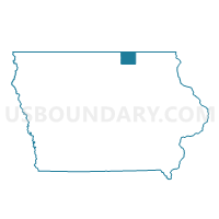
MITCHELL TWP Voting District, Mitchell County, Iowa
About
Outline

Summary
| Unique Area Identifier | 582850 |
| Name | MITCHELL TWP Voting District |
| County | Mitchell County |
| State | Iowa |
| Area (square miles) | 27.84 |
| Land Area (square miles) | 27.68 |
| Water Area (square miles) | 0.16 |
| % of Land Area | 99.41 |
| % of Water Area | 0.59 |
| Latitude of the Internal Point | 43.33478370 |
| Longtitude of the Internal Point | -92.84023430 |
Maps


Graphs
Select a template below for downloading or customizing gragh for MITCHELL TWP Voting District, Mitchell County, Iowa


Neighbors
Neighoring Voting District (by Name) Neighboring Voting District on the Map
- BURR OAK TWP Voting District, Mitchell County, IA
- CEDAR TWP Voting District, Mitchell County, IA
- LIBERTY TWP & STACYVILLE TWP W/O STACYVILLE Voting District, Mitchell County, IA
- OSAGE TWP Voting District, Mitchell County, IA
- ROCK TWP Voting District, Mitchell County, IA
- ST. ANSGAR TWP Voting District, Mitchell County, IA
Top 10 Neighboring County Subdivision (by Population) Neighboring County Subdivision on the Map
- Osage township, Mitchell County, IA (3,934)
- St. Ansgar township, Mitchell County, IA (1,393)
- Cedar township, Mitchell County, IA (575)
- Mitchell township, Mitchell County, IA (363)
- Rock township, Mitchell County, IA (304)
- Burr Oak township, Mitchell County, IA (247)
- Liberty township, Mitchell County, IA (231)